Suche Messwerte Kataloge Über MDI-DE Partner Datenquellen
Hilfe Kontakt Impressum Datenschutz Barrierefreiheit
MDI-DE MDI-DE MDI-DE
Suche
Messwerte
Kataloge
Über MDI-DE
Alle Suchergebnisse
Geodatensatz

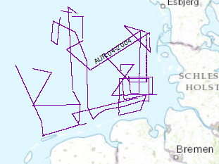
Processed seismic data of Cruise AUR 2004

Inhalt
  • Übersicht
  • Be­schrei­bung
    Aktualität der Daten Aktualität des Datensatzes
  • Raumbezug
  • Verweise und Downloads
    Weitere Verweise
  • Nutzung
  • Kontakt
    Point of Contact
  • Fach­infor­mationen
    Informationen zum Datensatz Zusatzinformationen Schlag­worte
  • Metadatensatz

Nutzungs­bedingun­gen

Allgemeine Geschäftsbedingungen, siehe https://www.bgr.bund.de/AGB - General terms and conditions, see https://www.bgr.bund.de/AGB_en. Die bereitgestellten Informationen sind bei Weiterverwendung wie folgt zu zitieren: Datenquelle: AUR04, (c) BGR, Hannover, 2004

Point of Contact

Federal Institute for Geosciences and Natural Resources

Marine_Seismik@bgr.de

Vorschau

img

Be­schrei­bung

AUR04 2004

Continuing the systematic work which was started during a previous BGR expedition with RV AURELIA in Sept./Oct. 2003 the late Tertiary and Quaternary development of the German EEZ was further investigated by seismic profiling. The data format is Society of Exploration Geophysicists SEG Y. Again the research vessel AURELIA was chartered for a period of 21 days from 31st of May to 19th of June 2004. During the cruise the grid of seismic profiles which was aquired in 2003 was completed and data gaps were closed. A total of 2618km of high quality MCS lines were surveyed.


Zur Erkundung der Entwicklung der deutschen ausschließlichen Wirtschaftszone im Tertiär und im Quartär wurden in der Zeit vom 31.05.2004 bis 19.06.2004 seismische Vermessungen mit FS Aurelia vorgenommen. In dieser Zeit wurden 2618 km hochauflösender Mehrkanalseismik (Format SEG-Y) aufgenommen. Dieses Projekt steht in enger Verbindung zu dem Datensatz der im September/Oktober 2003 mit FS Aurelia aufgenommen wurde.

Aktualität der Daten

Status

completed

Aktualität des Datensatzes

Creation

19.06.2003

Raumbezug

Lage der Geodaten (in WGS84)
SW Länge/Breite NO Länge/Breite
4.463°/53.442° 8.275°/55.479°
Koordinaten­system
EPSG:4326

Verweise und Downloads

Weitere Verweise (54)

AUR04 2004 (Shapefile) [3.0 MB] Download of data AUR04 2004 im Format ESRI Shape
http://www.geo-seas.eu/v_cdi_v3/print_ajax.asp?n_code=1301991 Information Profile AUR04-01
http://www.geo-seas.eu/v_cdi_v3/print_ajax.asp?n_code=1301992 Information Profile AUR04-02
http://www.geo-seas.eu/v_cdi_v3/print_ajax.asp?n_code=1301993 Information Profile AUR04-03
http://www.geo-seas.eu/v_cdi_v3/print_ajax.asp?n_code=1301994 Information Profile AUR04-04
http://www.geo-seas.eu/v_cdi_v3/print_ajax.asp?n_code=1301995 Information Profile AUR04-5A
http://www.geo-seas.eu/v_cdi_v3/print_ajax.asp?n_code=1301996 Information Profile AUR04-06
http://www.geo-seas.eu/v_cdi_v3/print_ajax.asp?n_code=1301997 Information Profile AUR04-07
http://www.geo-seas.eu/v_cdi_v3/print_ajax.asp?n_code=1301998 Information Profile AUR04-08
http://www.geo-seas.eu/v_cdi_v3/print_ajax.asp?n_code=1301999 Information Profile AUR04-09
http://www.geo-seas.eu/v_cdi_v3/print_ajax.asp?n_code=1302000 Information Profile AUR04-10
http://www.geo-seas.eu/v_cdi_v3/print_ajax.asp?n_code=1302001 Information Profile AUR04-11
http://www.geo-seas.eu/v_cdi_v3/print_ajax.asp?n_code=1302002 Information Profile AUR04-12
http://www.geo-seas.eu/v_cdi_v3/print_ajax.asp?n_code=1302003 Information Profile AUR04-13
http://www.geo-seas.eu/v_cdi_v3/print_ajax.asp?n_code=1302004 Information Profile AUR04-14
http://www.geo-seas.eu/v_cdi_v3/print_ajax.asp?n_code=1302005 Information Profile AUR04-15
http://www.geo-seas.eu/v_cdi_v3/print_ajax.asp?n_code=1302006 Information Profile AUR04-16
http://www.geo-seas.eu/v_cdi_v3/print_ajax.asp?n_code=1302007 Information Profile AUR04-17
http://www.geo-seas.eu/v_cdi_v3/print_ajax.asp?n_code=1302008 Information Profile AUR04-18
http://www.geo-seas.eu/v_cdi_v3/print_ajax.asp?n_code=1302009 Information Profile AUR04-19
http://www.geo-seas.eu/v_cdi_v3/print_ajax.asp?n_code=1302010 Information Profile AUR04-20
http://www.geo-seas.eu/v_cdi_v3/print_ajax.asp?n_code=1302011 Information Profile AUR04-21
http://www.geo-seas.eu/v_cdi_v3/print_ajax.asp?n_code=1302012 Information Profile AUR04-22
http://www.geo-seas.eu/v_cdi_v3/print_ajax.asp?n_code=1302013 Information Profile AUR04-23
http://www.geo-seas.eu/v_cdi_v3/print_ajax.asp?n_code=1302014 Information Profile AUR04-24
http://www.geo-seas.eu/v_cdi_v3/print_ajax.asp?n_code=1302015 Information Profile AUR04-25
http://www.geo-seas.eu/v_cdi_v3/print_ajax.asp?n_code=1302016 Information Profile AUR04-26
http://www.geo-seas.eu/v_cdi_v3/print_ajax.asp?n_code=1302017 Information Profile AUR04-27A
http://www.geo-seas.eu/v_cdi_v3/print_ajax.asp?n_code=1302018 Information Profile AUR04-27
http://www.geo-seas.eu/v_cdi_v3/print_ajax.asp?n_code=1302019 Information Profile AUR04-28
http://www.geo-seas.eu/v_cdi_v3/print_ajax.asp?n_code=1302020 Information Profile AUR04-29
http://www.geo-seas.eu/v_cdi_v3/print_ajax.asp?n_code=1302021 Information Profile AUR04-30
http://www.geo-seas.eu/v_cdi_v3/print_ajax.asp?n_code=1302022 Information Profile AUR04-31
http://www.geo-seas.eu/v_cdi_v3/print_ajax.asp?n_code=1302023 Information Profile AUR04-32
http://www.geo-seas.eu/v_cdi_v3/print_ajax.asp?n_code=1302024 Information Profile AUR04-33
http://www.geo-seas.eu/v_cdi_v3/print_ajax.asp?n_code=1302025 Information Profile AUR04-34
http://www.geo-seas.eu/v_cdi_v3/print_ajax.asp?n_code=1302026 Information Profile AUR04-35
http://www.geo-seas.eu/v_cdi_v3/print_ajax.asp?n_code=1302027 Information Profile AUR04-36
http://www.geo-seas.eu/v_cdi_v3/print_ajax.asp?n_code=1302028 Information Profile AUR04-37A
http://www.geo-seas.eu/v_cdi_v3/print_ajax.asp?n_code=1302029 Information Profile AUR04-37
http://www.geo-seas.eu/v_cdi_v3/print_ajax.asp?n_code=1302030 Information Profile AUR04-38
http://www.geo-seas.eu/v_cdi_v3/print_ajax.asp?n_code=1302031 Information Profile AUR04-39
http://www.geo-seas.eu/v_cdi_v3/print_ajax.asp?n_code=1302032 Information Profile AUR04-40A
http://www.geo-seas.eu/v_cdi_v3/print_ajax.asp?n_code=1302033 Information Profile AUR04-40
http://www.geo-seas.eu/v_cdi_v3/print_ajax.asp?n_code=1302034 Information Profile AUR04-41
http://www.geo-seas.eu/v_cdi_v3/print_ajax.asp?n_code=1302035 Information Profile AUR04-42
http://www.geo-seas.eu/v_cdi_v3/print_ajax.asp?n_code=1302036 Information Profile AUR04-43
http://www.geo-seas.eu/v_cdi_v3/print_ajax.asp?n_code=1302037 Information Profile AUR04-44
http://www.geo-seas.eu/v_cdi_v3/print_ajax.asp?n_code=1302038 Information Profile AUR04-45
http://www.geo-seas.eu/v_cdi_v3/print_ajax.asp?n_code=1302039 Information Profile AUR04-46
http://www.geo-seas.eu/v_cdi_v3/print_ajax.asp?n_code=1302040 Information Profile AUR04-47
http://www.geo-seas.eu/v_cdi_v3/print_ajax.asp?n_code=1302041 Information Profile AUR04-48
https://download.bgr.de/bgr/marineseismik/info/message_na.html Information Profile AUR04-05
https://services.bgr.de/geophysik/mssp Information Karte im BGR-Geoviewer
Identifikator des über­geordneten Metadaten­satzes

06a73c56-06a2-40d8-b806-466222b0760d

Nutzung

Nutzungs­bedingun­gen

Allgemeine Geschäftsbedingungen, siehe https://www.bgr.bund.de/AGB - General terms and conditions, see https://www.bgr.bund.de/AGB_en. Die bereitgestellten Informationen sind bei Weiterverwendung wie folgt zu zitieren: Datenquelle: AUR04, (c) BGR, Hannover, 2004

Zugriffs­beschränkun­gen

no limitations to public access

Kontakt

Point of Contact

Federal Institute for Geosciences and Natural Resources

Stilleweg 2
30655 Hannover

Marine_Seismik@bgr.de

Fach­infor­mationen

Informationen zum Datensatz

Identifikator

9758be03-e9e8-4cf4-aa2f-23e1e6cd6299

Digitale Repräsentation

Vector

Fachliche Grundlage

During the period from 31st May to 19th of June 2004 BGR acquired seismic lines in the North Sea. The Lines AUR04-01, AUR04-02, AUR04-03, AUR04-04, AUR04-06, AUR04-07, AUR04-08, AUR04-09, AUR04-10, AUR04-11, AUR04-12, AUR04-13, AUR04-14, AUR04-15, AUR04-16, AUR04-17, AUR04-18, AUR04-19, AUR04-20, AUR04-21, AUR04-22, AUR04-23, AUR04-24, AUR04-25, AUR04-26, AUR04-27, AUR04-27A, AUR04-28, AUR04-29, AUR04-30, AUR04-31, AUR04-32, AUR04-33, AUR04-34, AUR04-35, AUR04-36, AUR04-37, AUR04-37A, AUR04-38, AUR04-39, AUR04-40, AUR04-40A, AUR04-41, AUR04-42, AUR04-43, AUR04-44, AUR04-45, AUR04-46, AUR04-47, AUR04-48 are processed (migrated) at BGR, whereas AUR04-05, AUR04-05A are raw data.

Zusatzinformationen

Sprache des Daten­satzes

Englisch

Kon­formi­tät
Spezifi­kation der Kon­formi­tät Spezifi­kations­datum Grad der Kon­formi­tät Geprüft mit
VERORDNUNG (EG) Nr. 1089/2010 DER KOMMISSION vom 23. November 2010 zur Durchführung der Richtlinie 2007/2/EG des Europäischen Parlaments und des Rates hinsichtlich der Interoperabilität von Geodatensätzen und -diensten 08.12.2010 siehe dazu die angegebene Durchführungsbestimmung
Datenformat
Name Version Kompressionstechnik Spezi­fikation
Shapefile n/a

Schlag­worte

INSPIRE-Themen Geology Geology
GEMET-Concepts geophysics Geophysik marine geology Meeresgeologie raw material Rohstoff
ISO-Themen­kategorien Geoscientific Information
Suchbegriffe Deutsche AWZ GeolDG German EEZ MSSP Nordsee North Sea seismics Seismik two-dimensional seismic reflection zweidimensionale Reflektionsseismik

Informationen zum Metadatensatz

Objekt-ID

665c5507-08dc-416f-8296-9991f5cd8814

Aktualität der Metadaten

04.03.2024

Sprache Metadatensatz

Englisch

Datensatz / Datenserie  

Dataset

XML Dar­stellung
Metadaten als XML herunter­laden
Point of Contact (Metadatum)
geodatenmanagement@bgr.de
Metadatenquelle
Bundesanstalt für Geowissenschaften und Rohstoffe
bu_bgr

Hilfe Kontakt Impressum Datenschutz Barrierefreiheit

Hilfe