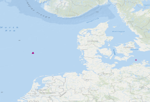
The dataset includes the locations of OBS stations (Ocean Bottom Seismometers) operated in the German Bight during cruise MSM100 with R.V. Maria S. Merian. The time interval from 13.05.2021 to 15.05.2021 has been analysed in a phase without airgun operation for passive recording with 4.5 Hz geophones. Furthermore, the dataset contains locations of 3 broadband OBS systems which were operated during an experiment at the Darss ramp in the German Baltic Sea. The records were analysed in the time interval 23.01.2018 to 01.04.2018.
Der Datensatz beinhaltet die Positionen der Ozeanboden-Seismometer (OBS-Sensoren), die während der Fahrt MSM100 im Projekt GeoBasis3D mit der Maria S. Merian im Jahr 2021 in der Deutschen Bucht ausgebracht wurden. Analysiert wurde der Zeitraum vom 13.05.2021 bis zum 15.05.2021 im Rahmen des Geostor-Projektes, in dem keine Airguns betrieben wurden und rein passive Aufzeichnungen vorliegen. Weiterhin enthält der Datensatz die Positionen von 3 OBS-Geräten aus einem Experiment an der Darsser Schwelle in der Deutschen Ostsee, deren Aufzeichnungen aus dem Zeitraum vom 23.01.2018 bis zum 01.04.2018 analysiert wurden.
Raumbezug
Lage der Geodaten (in WGS84)
| SW Länge/Breite | NO Länge/Breite | |
|---|---|---|
| 4.657°/54.7° | 12.695°/55.259° |
| Koordinatensystem |
|---|
Verweise und Downloads
Querverweise (1)
Geodatensatz
OBS stations of the GEOSTOR project in the German Bight and in the German Baltic Sea
The dataset includes the locations of OBS stations (Ocean Bottom Seismometers) operated in the German Bight during cruise MSM100 with R.V. Maria S. Merian. The time interval from 13.05.2021 to 15.05.2021 has been analysed in a phase without airgun operation for passive recording with 4.5 Hz geophones. Furthermore, the dataset contains locations of 3 broadband OBS systems which were operated during an experiment at the Darss ramp in the German Baltic Sea. The records were analysed in the time interval 23.01.2018 to 01.04.2018.
Weitere Verweise (4)
https://geostor.cdrmare.de/
Information
Geostor-Webseite
https://geostor.cdrmare.de/data
Information
Geostor-Datenkatalog
Nutzung
| Nutzungsbedingungen |
Datenlizenz Deutschland Namensnennung 2.0Quellenvermerk: GEOSTOR-OBS Dieser Datensatz kann gemäß der Lizenz "Datenlizenz Deutschland Namensnennung 2.0" (https://www.govdata.de/dl-de/by-2-0) genutzt werden. |
|---|
| Zugriffsbeschränkungen |
no limitations to public access |
|---|
Kontakt
Fachinformationen
Informationen zum Datensatz
| Art des Dienstes |
View Service |
|---|
| Version |
OGC:WMS 1.3.0 |
|---|
| Fachliche Grundlage |
During the period from the 13th May to the 15th May 2021, BGR has operated Ocean Bottom Seismometers (OBS stations) in the German Bight during the project GeoBasis3D. In a phase without airgun operation for passive recording with 4.5 Hz geophones, the data were analysed. Furthermore, experiments with 3 broadband OBS systems have been made at the Darss ramp in the German Baltic Sea. The recorded data were analysed in the time interval from 23.01.2018 to 01.04.2018. |
|---|
Operation
| Name der Operation | Beschreibung der Operation | Aufruf der Operation |
|---|---|---|
| GetCapabilities | ||
| GetMap |
| GetCapabilities Dokument | Kartenansicht öffnen |
|---|

